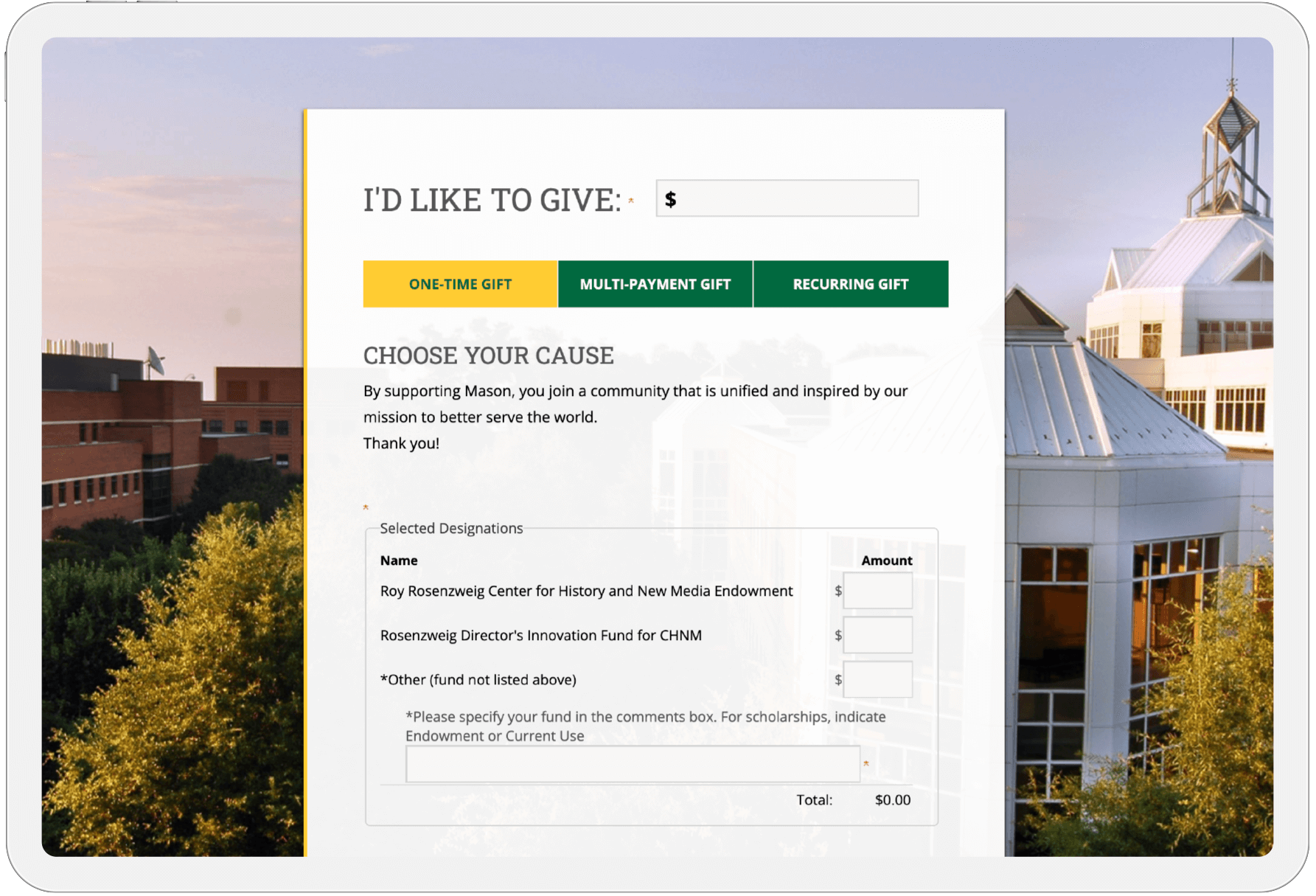
« Wright American Fiction, 1851-1875, Liz | Main | Copyright....some rights reserved. »
November 07, 2005
David Rumsey Map Archive - Kurt
I selected the David Rumsey Historical Map Collection for this project. David Rumsey started collecting maps in the 1980s. His collection continued to grow and in 2000 he launched a website to provide access to the collection on line. It provides a searchable archive of currently over 12600 maps and images. There are several ways to access the collection including a browser based viewer, a downloadable java client that offers the most features for analysis, and a GIS viewer. The collection is searchable by numerous methods such as by country, state, keywords, and by any of the data fields stored for each map such as publication date, author, and title among others. The search function also allows for numerous qualifiers such as equals, contains, less than, etc. Have no doubt if one is interested in maps as a research tool this is one dangerous site. It will draw you in and not let go.
While evaluating the site I had to explore some of their other tools in development such as the 3D navigator which takes historic maps and stretches them over topographical relief data thereby creating 3D versions of the historic maps that one can “fly through.” Another tool overlays numerous maps of the same area from different periods and plays them back as a movie of sorts showing the changes through time. This is only available for select locations such as Washington, DC but the effect is amazing.
If I were to use this site for a project I would most likely make use of their downloadable java client that allows for numerous maps to be displayed in the same window. You can zoom into specific areas with no loss of resolution. Extensive metadata about each map can also be displayed in that window. In addition you can create your own collections based on what you selected and you can download the images as well.
One project that I would consider doing would be to evaluate how maps of the Pamunkey River area of Virginia located just northeast of Richmond depict changes through time. Early maps of the period show the location of Indian villages, churches, villages, bridges, ferries, and numerous other culturally significant sites. Over time as the native villages disappear completely from the maps in the mid 18th century other businesses develop in those areas. One example is the development of Tod’s Bridge. From map to map we see the changes as Tod’s Ordinary and Tod’s Warehouse are added. Later the area is simply labeled Tod’s Bridge and then disappears altogether. Cartographers had certain priorities in mind when making their maps but their choices in what to display and not display can be indicators of their culture. One map indicates the locations of public worship sites and mills while other maps indicate who owned ferries at key river crossings. Research into county and state records could supplement the maps and create a more complete picture of how land and water use changed through time.
While one could do this analysis by directly studying the maps themselves the effort in obtaining access to them at several locations would be tremendous. This site along with its cache of tools greatly enhances a historian’s ability to not only answer questions but create new ones that might not have occurred to them without taking the time to “play” with the maps. No doubt the Library of Congress offers an equally impressive collection and no serious study such as the one I propose could be considered complete by only accessing the David Rumsey site but it could also be said that no serious study of this topic could ignore it either.
This site does require some investment in time to download some of the tools and decide which of the many viewing options would work best. The really flashy tools can only be applied to short list of selected maps but their list is growing. One of the site’s best attributes is the way it encourages the study of maps. David Rumsey’s article and excerpts from his book Cartigraphica Extraodinaire are well worth the read and have in fact sold me on the book, “maps serve as time machines, transporting us hundreds of years into the past and showing us extraordinary views of history through the eyes of the mapmakers of the time.”
Here are a few samples related to Tod’s bridge.

1736.

1755.

1776.

1827. See highlighted area for probable location for Tod's Bridge.
Posted by kknoerl at November 7, 2005 12:56 PM