 |
|||||||||||||||||||
 |
|||||||||||||||||||
 |
|||||||||||||||||||
|
|||||||||||||||||||
 |
|||||||||||||||||||
|
Maps reflect the particularity of broader geographic knowledge of the time. For example, maps dating before the 15th century typically reflected (and reinforced) the certainty that the earth was flat. Medieval European maps were often more allegorical or ecclesiastical than cartographic, as in the 12th-century map below. 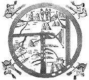 [Click to Enlarge] We can thus “read” a historical map not only for insight into the particular mapmaker’s skill and imagination, but as a window into the bigger worldview and cultural context within which the map was produced.
Most of the formal elements of cartography (scales, compasses, legends) reflect relatively modernist (post-15th century) and Western traditions. In the very earliest maps, space is fluid, there are no regular mathematical principles that determine the location and sizes of places, and “directionality” in our modern sense is almost entirely absent. The world’s earliest surviving maps, starting with ancient Babylonian clay tablets from the 6th century BCE through early Greek maps of the 3rd century BCE, typically show the world as a small landmass entirely encircled by a ribbon of water, as in the map below. The 5th century BCE Babylonian map below places Babylon at the center of the flat, round universe, with seven outer “islands” that reflect sketchy knowledge of other continents. On maps such as these there is no “up” as such, and the relationship of objects to one another is confusing to a modern reader, but the earliest maps provide important clues to the worldviews of early cultures. 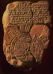 [Click to Enlarge] As part of our critical use of maps as historical sources, it is crucial to ask questions about the provenance and purpose of maps. Some of the evidence, above, about the style, language, and materials provide obvious clues to the nature and origins of historical maps. But sometimes a critical reader needs to be more interpretive.
Sometimes the purpose of a map seems to be straightforwardly geographical and unremarkable: as today, some maps in the past were made for purposes simply of “getting around” and as a record of where things are. But until recently, maps were relatively expensive to produce and required the efforts of skilled tradespeople to produce them. The “incidental” and mass production of maps, such as the ubiquitous placemat maps that we find today on tables at tourist roadside restaurants, is very much a modern hallmark.
One of the first things to remember is that most mapmakers were “egocentric” in their mapmaking. So, for example, on a 19th-century Dutch world map, Western Europe would almost invariably be at the focal center of the map. But all mapmaking cultures tend to reflect self-referential centering. The Chinese “Jingban tianwen quantu” map from the 1780s, below, is a wonderful illustration of this: at the top of this map is a two-hemisphere view of the world; in both the eastern and western hemispheric view, China takes up most of the map with all the other continents squeezed into the edges. This map also illustrates the Chinese cartographic convention of including considerable narration on the map itself; European maps of the same time typically include very little writing (other than locational identifiers). 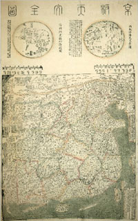 [Click to Enlarge]
In the late 1500’s Gerhard Mercator, a Flemish geographer, developed a map projection that represented a remarkable advance in navigation and map reliability—but it was one that also standardized Eurocentric representation on world maps.  [Mercator Projection - Click to Enlarge]
The Mercator projection distorts the geography of the northern latitudes, making Europe appear much larger than it really is—Greenland at 16 times its actual size, for example. The dominance of the Mercator projection has been challenged recently by projections that try to counter this Eurocentrism; one of the most prominent being the Peters projection, below, but this map too distorts geographical relationships by distorting shapes of countries and continents. All map projections distort something—size, shape, relative location— simply because of the mathematics of reproducing a sphere (the world) on a flat piece of paper (the map). 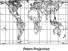 [Click to Enlarge] Just as narratives are authored, so are maps. Most of the maps we encounter in daily life today are mass produced by anonymous workers as part of a commercial map-production process. But maps dating from the 19th century or earlier tended to be produced one at a time or in small batches, were often hand-colored by map colorists (an occupation in itself), often produced for a specific purpose and commissioned by a specific political figure or commercial company, and were often considered to be works of art. Some individual mapmakers achieved great fame and prominence. The direct authorship of many surviving historical maps is well known, and historians of cartography can identify the handiwork of specific mapmakers by the style and detail of surviving maps. Maps are palettes for the artistic, sometimes quirky, imagination of their author. The 12th-century map of the world, below, is a particularly fanciful combination of cartography, myth, and religious belief. Typical of these earliest maps, the known world is shown entirely encircled by water, with continents arranged in what appears to be a random pattern; one of the main features of the map is the placement of Eden at the top. [Click to Enlarge]
Even if we don’t know the mapmaker as an individual figure, maps are “authored” in a broader conceptual sense. The richly colored, ornate maps that survive in historical collections today tend to be maps that were produced by and for elites. Historically, only a small subset of the population in most countries had the resources to make, read, or commission formal maps. Maps that were produced for specific purposes of consolidating commercial or political power were the most “valuable” and thus are the most likely to have survived into today’s archival collections. Ordinary maps, vernacular maps, and informal maps are less likely to be available to today’s historian. A large share of the maps that survive in Western collections today are “exploration and discovery” maps—maps created by European explorers who were scouring the world in the name of commercial or colonial conquest. Many of these maps were designed to inventory the populace, the resources, and the commercial opportunities available in new lands.
Maps don’t just reflect reality, they also shape it. Maps didn’t just record the encounter with new geographies; they played an active role in shaping it. Mapping was an essential tool in the European colonial expansion around the globe from the 15th through the 20th centuries. The first nation or commercial interest to produce a map of a new place could thereby claim ownership of it, and the race to produce a reliable map of new territories was often intense and bloody.
Sometimes the colonial, military, or commercial purpose of a map is immediately apparent in the map itself. But not all maps serve this purpose. Many maps seem to simply offer a record of landscapes and places in a rich visual presentation—a snapshot of a place many centuries before photography was invented. Even then, however, there are key questions to ask about the circumstances under which the map was made.
Was this map made by an insider or an outsider? Was a map made “by” the people who live there, or is it a map “of” the place made by outsiders? Posing these questions can offer insight into the purpose of a map and also into its accuracy. The extent to which a map is a faithful record of real landscapes and places (and thus might be used as an accurate historical artifact) may depend on whether it was made with an insider’s knowledge or an outsider’s imagination. “Outsider” mapmakers often filled up landscapes with imaginary creatures and fictional features, as we will see in the interpretive model below. As Jonathan Swift remarks: So geographers in Afric-maps, With savage pictures fill their gaps; And o’er unhabitable downs, Place elephants for want of towns. Many indigenous cultures were destroyed in the process of European colonial expansion and we just don’t know what kind of mapmaking traditions they may have had. The Mayans of pre-Columbian Central and South America, for example, were a large and complex society that no doubt had maps. However only a handful of intact Mayan manuscripts of any type survived the Spanish conquest, none of them with maps.
|
||||||||||
 Download Essay
|
finding world history | unpacking evidence | analyzing documents | teaching sources | about |
||