|
|
|
In addition to being influenced by its “purpose”, what is on any given map is influenced by a broader cultural or scientific knowledge or worldview of the time. For example, in the 17th century, most educated Western Europeans believed that there was an open polar sea at the north pole. This was the conventional scientific wisdom of the time. In consequence, maps of the Arctic routinely featured this sea, despite there being no actual evidence of its existence. In turn, the fact that so many maps showed an open polar sea reinforced the certainty with which its existence was argued. Maps have a circular and reciprocal relationship to received knowledge.
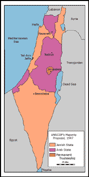
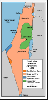
Maps are often central props in political conflicts. Today, for example, official maps in both Pakistan and India routinely include Kashmir as part of their national territory; where the West Bank boundary is drawn on Israeli or on Jordanian maps can be a matter of considerable geopolitical consequence. Indeed, maps were the main currency of geopolitical discussions around the creation of the state of Israel in the late 1940s—negotiators for British, Arab, Jewish, UN, and USA interests routinely traded maps with sometimes wildly varying boundary proposals as a way of pushing forward negotiations.
1947 and 1949 Partitions of Israel
[Click on the picture(s) to enlarge]
Geographers and historians often call on the maxim that “the map is not the territory,” but much of human history has proceeded as though it was.
 
|


 Download Essay